In July
I'll be traveling to Iceland with my girlfriend, Becca! We both share a passion
for travelling to learn about new cultures and explore nature across the world.
Together we've camped on the beautiful lakes of Algonquin, and explored cities
in Holland, Belgium, and the UK.
We'll be
travelling to Iceland to hike the Laugavegurinn trail, Iceland's most popular
hiking trail. A popular pilgrimage both for locals looking to be reminded of
the brutality of the highlands, and foreigners wanting to glimpse the variety
of Icelandic countryside. Along the way we'll spend two days exploring the
capital of Reykjavik, and three days driving to the sites of western and
southern Iceland.
On the
trip we hope to learn about the Icelandic culture, explore it's natural
wonders, take part in the tradition of hiking the Laugavegurinn under the
midnight sun, and meet other like minded travelers.
Despite Iceland being relatively pricey to visit I managed to make a plan that won't break the bank (spending four days in a tent definitely helps any budget). The price per person (excluding food, entertainment etc...) comes out to, $1,519.94. The breakdown is; Flight In $231, Flight out $440, Hotel $576, Car Rental $85.27, Bus Tickets $126.79, Camping Fees $60.88. Thanks to previous camping experience and Canada's cold climate we already have all the gear we'll need for the hiking and camping.
 |
| The city of Reykjavik http://forgetsomeday.com/exploring-iceland-downtown-reykjavik/ |
The City
We'll fly
in to Reykjavik from London on Friday, July 8th, and spend Saturday and Sunday
exploring the world's most northern capital city. After being a visitor in a
lot of cities Becca and I have realized that the best way (at least for us) to
get the feel of a city is to just explore it! So in that spirit we have very
little planned for the city. The few things we do have to do are,
 |
| See the city from the bell tower of the Hallgrimskirkja https://upload.wikimedia.org/wikipedia/en/c/ca/Reykjavik's-church.jpg |
 |
| Have breakfast at the Laundromat; half laundromat half atmospheric cafe http://www.icelandguest.com/library/Images/Travel-guide/Dining/Cafes-and-bars/Laundromat054K7235.jpg?Proc=2d35c507-f7d1-454b-88a9-734b0917af7d |
 |
| See the Sun Voyager sculpture. A monument to exploration http://static.travel.usnews.com/images/destinations/193/sun_voyager.jpg |
 |
| Walk around Tjornin, a small lake at the center of the city https://upload.wikimedia.org/wikipedia/commons/9/91/Tj%C3%B6rnin,_Reykjavik.jpg |
 |
| Have lunch at Baejarins Bextu Pylsur, a famous hot dog stand http://bbp.is/wp-content/uploads/2011/08/IMG_4718-baejarins-beztu-pylsur-670x446.jpg |
 |
| Have dinner at Saegreifinn. A sea food Resturaunt in the harbour famous for its lobster soup http://www.kulturbrause.de/wp-content/uploads/2013/07/reykjavik_saegreifinn.jpg |
And lastly, explore the nightlife in hopes of finding live music!
Road Trip
Over the
next three days we'll be driving to the area's surrounding Reykjavik seeing the
sites!
Day Three - Southwestern Iceland
 |
| Deildartunguhver, the highest flowing hot spring in Europe http://for91days.com/photos/Iceland/Deildartunguhver%20and%20Hraunfoss/Deildartunguhver%20and%20Hraunfoss%20-%2001-20130821%20for91days.com.jpg |
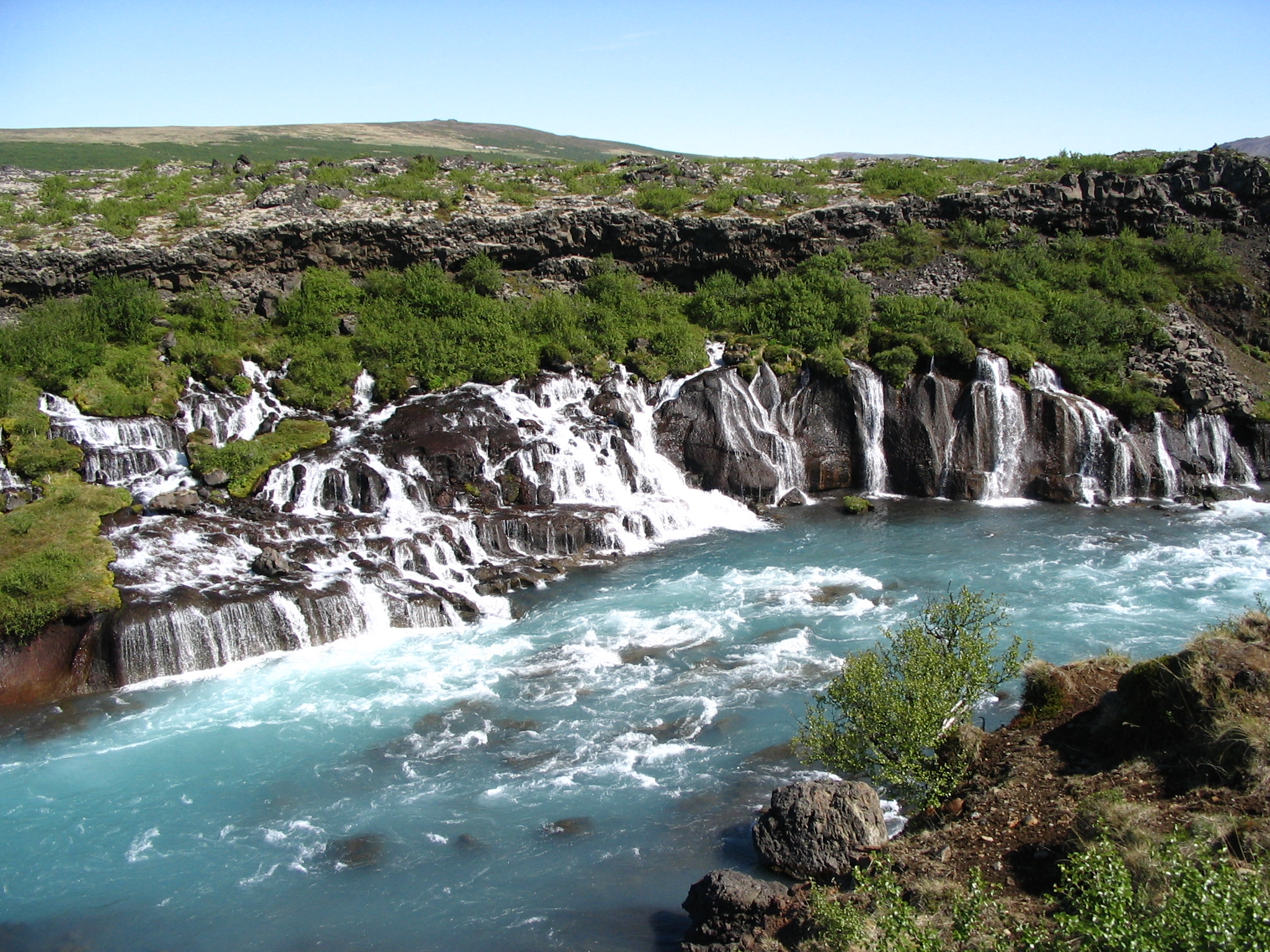 |
| Hraunfossar, also known as Lava Falls, a slow cascade of water falling through the moss covered rocks leading to Barnafoss, a larger and more violent set of waterfalls https://upload.wikimedia.org/wikipedia/commons/b/bb/Iceland_Hraunfossar_2.jpg |
 |
| Grabrok, a volcanic crater complete with walking path http://media-cdn.tripadvisor.com/media/photo-s/06/d3/eb/d7/grabrok-crater.jpg |
Day Four - Southern Iceland
 |
| Geysir, the site of The Great Geysir, which erupts around three times a day, and the Strokkur, which erupts every few minutes http://www.roughguides.com/wp-content/uploads/2013/01/98841597-1680x1050.jpg |
 |
| http://www.gullfoss.is/wp-content/uploads/2013/04/gullfoss.jpg Gullfoss, one of Iceland's most popular waterfalls |
Day Five - Southern Iceland Continued
 |
| Seljalandsfoss, one of Icelands most well-known waterfalls. It falls sixty meters and there is a path going behind the falls https://upload.wikimedia.org/wikipedia/commons/6/69/Seljalandsfoss,_Su%C3%B0urland,_Islandia,_2014-08-16,_DD_201-203_HDR.JPG |
 |
| Reynisfjara, an absolutely stunning stack of basalt columns shaped into pyramid like blocks. According to folklore the stacks were created from two trolls turned to stone by the daybreak http://www.supercoolbeaches.com/sites/default/files/reynisfjara-beach-iceland.jpg |
The Laugavegurrin Trail
The Gear
Due to the extreme conditions of the Icelandic highlands the proper gear is paramount for safely finishing the trail.
Hiking boots and waterproof shoes for crossing rivers
Raincoat and pants, weatherproof jacket, sunglasses, tuque and two sets of warm layered clothing
Four season sleeping bag
Weather and windproof tent
Waterproof lined backpack
Food, and a 2 liter water bottle
Cooking gear
Toiletries
First Aid Kit
Survival Kit - survival blanket, whistle, paper, pencil, high energy food
Thanks to the Canadian climate we already have all the gear we need.
The Trek
On day
six we drive to the beginning of the Laugavegurrin trail early in the morning.
We'll hike for 12 km passing through lava fields, a geothermal hot spring, and
climbing Brennisteinsalda. Although
there are cabins to stay in along the trail we decided that we would use the
designated camp sites instead. A cabin which could be housing 75 people who have been hiking all day just doesn't sound too appealing.
 |
| The view from Brennisteinsalda http://static.thousandwonders.net/Brennisteinsalda.original.1218.jpg |
The next
day will be another 12 km hike through snowy ravines, and pass over the
Haskeroingur and Rhyolite mountains. During the peak
season of July and August as many as 100 hikers can be expected to start on the Laugavegurrin
trail every day which should provide a great opportunity to meet a variety of
people on the trail and in the camps.
 |
| The Rhyolite Mountains http://en.people.cn/mediafile/201209/05/F201209051342022052285832.jpg |
The
third day is a 15 km walk over the Brattháls ridge, and through the Bratthálskvísl river.
 |
| Brattháls Ridge http://cdn.c.photoshelter.com/img-get2/I0000FYuHpacbvt0/fit=1000x750/Iceland-South-Fjallabak-D3X1197.jpg |
The
final day is a 15km walk through the Syðri-Emstruá
canyon, the Almenningar hills, the river Þröngá, and into Þórsmörk a mountain
range named after the Norse god Thor.
.jpg) |
| Þórsmörk https://upload.wikimedia.org/wikipedia/commons/c/cd/%C3%9E%C3%B3rsm%C3%B6rk_in_summer_2009_(12).jpg |
After spending the
night we will take a bus back to the beginning of the trail to get the car and
return to Reykjavik where we fly out after a good night's rest in an actual
bed.
On the trek we will
overcome a number of obstacles we've never seen before, we'll cross frozen
rivers, camp on windswept sandy plains,
and hike through the high altitude Icelandic weather which threatens
hypothermia even in the summer months.
In return not only
do we get the challenge but we also get to see some of the most unique scenery
in the world, and enjoy it under nineteen to twenty hours of sunlight. We're
excited to challenge ourselves and to learn about Icelandic culture in Reykjavik,
but also to learn about its culture through its primal nature.
Sources
All photo sources are posted under the respective photos
Flight prices are quotes from Google Flights
Hotel Prices are from Trip Advisor
Car Rental price is from arguscarhire.com
Bus ticket price is from https://travel.idega.is/window/7d3272b0-67d3-47e3-b3ab-3350c61af832?linkGeneratorProductId=2762